

First off, you probably might want to refresh, or learn about, the past two GPS tries HERE and HERE. One was an abject failure and the other did not measure up to my expectations or needs. I may refer to those two units in this review, so if you want to know, or be reminded, those two links will get you all you want to know and probably more.
Next: My Expectations -
I expect a GPS unit to be easy to use, have native turn-by-turn navigation for events and my own adventures, and to have a unit that is reliable and actually works. I don't expect to have to use a bunch of sensors. Seems simple enough, no? But my past two experiences left me......well, let's just say I have a bitter taste in my mouth.
Next, you need to understand me. I have a difficult relationship with technology. If there is a way for something to fail, get screwed up, or for it to hiccup, in any way, I can usually discover that unintentionally. I just have had a knack for getting things to fail or screw up which has left some people baffled. That's my special talent, so take any issues I may have with this new unit with that in mind.
Okay, so I have a Wahoo Elemnt ROAM now. The v2 unit. It is supposed to be Wahoo's best unit yet and it is the most expensive one I've yet tried at right at $400.00. (Again, this was sent to me to try out/review, see Standard Disclaimer) Okay, I'm not going to get into all the techy mumbo-jumbo here. If you want tech, go hit the link to the computer's webpage I provided in the hyperlink. Here I will just cover my user experience and contrast that with the Hammerhead and SIGMA experiences.
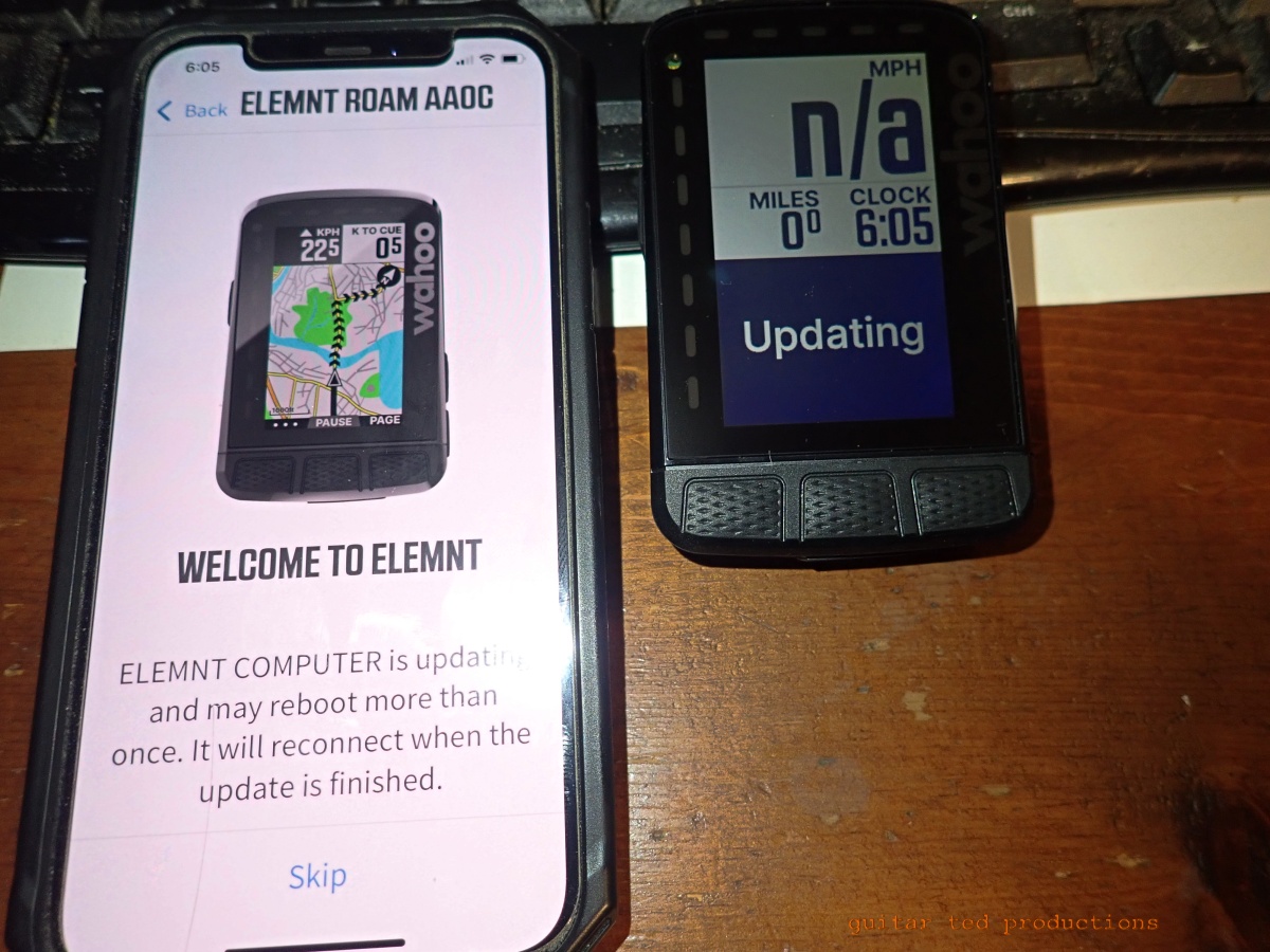 |
| Like most GPS computers these days, there is an app for that. |
Out Of The Box:
You get a "Quick Start" menu and really, that's all I needed to get up and running with this GPS unit. But before I get to that part, I will say that compared to the Karoo 2, this unit is slightly smaller and lighter. The Wahoo does not have a touch screen and that's just fine with me. Buttons work for me and as long as the UI is friendly I can navigate the buttons fine.
The screen is slightly smaller than the Karoo as well, but does that matter? We will see....
Set up was dead simple, fast, and satisfying. Then I wanted to link up to my Ride With GPS account, which Wahoo supports, and when the Elemnt ROAM asked for my Ride With GPS login, the screen shows two lines. The upper one is not labeled, but the lower one says "Password" under it. Hmm..... What does it want? My user name? That didn't work. It didn't occur to me until after about 15 minutes of frustration turning off and on things and changing passwords that it maybe wanted my email address. That worked.
Really? Label the data entry point and this could be a LOT smoother. I tell ya, it's always something......

But once that hurdle had been crossed hey! Presto! All my rides came over to the ROAM. Nice! WAY, way easier to do than Hammerhead's deal, and of course, far beyond the SIGMA Ride app's capabilities. (Note:SIGMA just released a new GPS that supposedly does upload routes better)
A word about the mounts. I got an "out front" and a zip tie mount. Both are nice and easy to install, but c'mon! A K-Edge made one costs 70 bucks?! Highway robbery. Really. That's outlandish.
I'll probably get another out front from Wahoo if this all pans out. That can come later. For now two mounts will have to do.
Ride Experience: I have not used the turn-by-turn feature yet because I wanted to get acquainted with the way the unit works outside of that. So, my ride Sunday was a test ride to see how the unit would fare. There were good things and not-so-good things which I will list in bullet point fashion now.
The Good:
- The color screen is great. Lots of map details. Even Waterloo's alleyways showed up! Bike paths are highlighted, and you get a zoom in - zoom out for good context and reference. That bit is not really "ride friendly". I'd recommend stopping to do that in a city as the small sized screen might require some study to get what you need out of it. Besides, staring at a screen is not a good thing while riding in a city, or anywhere, for that matter.
- The buttons are easy to understand from a bicycle saddle. The buttons on the face and sides have easily understood functions and the unit does not have confusing sub-pages and "apps" like Hammerhead does.
- The unit pauses and unpauses automatically, and I would say quickly "most of the time". (See below) On the whole, this feature worked much more quickly than it does on anything else I've used. Less than a second to pause, and less than a second "most of the time" to wake up again. You won't miss much of your ride because of a slow pause function here.
- The climb page is cool and I like that you get a preview of what is coming up so you can gauge your efforts accordingly. This is nice when you cannot see over the horizon to know if that is a false summit or if there is a downhill. With the climb page you'll know this. By the way, the "upcoming climb" thing hasn't been applicable since I haven't been on a route that has a climb that registers and I haven't followed a turn-by-turn route yet with a climb that would register that function. Stay tuned on that one.
- When you get out in the boonies the map automatically shifts to a "horizon mode" and goes to black and grey. I suppose that saves battery life, but whatever. There is a compass arrow and your speed up in the corner. Simple. I liked this screen the most as it was less distracting.
 |
| The map page has plenty of detail in the city. |
- Remember the pause function? Once, maybe twice, and this seemed to be more so out in the country, the unit was slow to "wake up". I counted six seconds in the one instance.
- The climb page would 'freeze' as in it would literally just stop at a random point and not continue streaming data. I had to scroll back through to the standard data page where the speed, time of day, and whatnot, was to get it back working again and then the climb page would skip the section from the point where it froze up, to the point you 'woke up' the computer again. So you lost that climb and descent data there for that time. (Or does it lose that segment where it was frozen? Once I was able to check on the app, the data seemed to be there?) This happened three times during a 34 mile ride. Maybe you "have to have" a sensor to keep that from happening? Maybe I was too far out in the boonies? Was it the heavy cloud cover?
- There is no onboard altimeter? Why? (Cumulative Altimeter/Elevation data, including Minimum/Maximum Elevation for a ride shows up in the ride's data page on the phone app though. And yes- there is an elevation graph, but no - I want an altimeter)
- The map page froze up once. Same deal as above.
- Zooming out the map page in the country seemed to be a problem because the unit appeared to bias toward the nearest towns and not keep my location centered. That was a bit confusing. I can see where that might be a useful thing, but let me decide. You can't, by the way. There is no way to move the map view at will. I'm not sure zooming out is of much use anyway because the map detail for gravel roads gets lost quickly and the thing is too tiny to read. I resorted to the map app on my phone instead which is 100% easier to read, easier to zoom out/in, and to move the map so you can plan your route.
- Lack of detailed instructions with the unit that you can hold in your hand and read outside of a digital device is a miss. I mean, how about a page that tells you what it is you will see on your screen? Like what the heck is "VAM". You might laugh because it seems obvious to you. I am not you. *See Note #1 below
- My Lezyne used to ask if you wanted to "save this ride" and if you selected "Yes", it automatically uploaded it to the Lezyne ROOT app. You then could hop on your PC/Mac and take a look at the detailed ride data. That was cool. I'm sure the Wahoo has this, why wouldn't it? * See Note #2
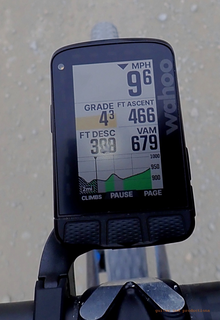 |
| The climb page was fun - when it was working. And what is "VAM" Volt/Amp Meter? |
So Far...
Okay, I like it, but I am concerned. This is a 400 dollar device. If this unit keeps up with the freezing pages thing, it will not fare well with me. Even if it does turn-by-turn stuff. That was annoying. If that issue wasn't present, I would be singing this units praises - so far. Of course, I have to try my test route for turn-by-turn before I will render a verdict here. That said, I want to like this thing, but yeah... Love the ease of use and the uploading of rides is seamless and dead simple. Obviously the freezing up is less than ideal.
 |
| The map page doesn't have much to show out in the boonies. |
Notes:
1: The Wahoo website has a ton of information on the Elemnt ROAM, but to find out what I am seeing on each page I had to make SIX clicks+ through other things to find what I wanted. The pages I had to navigate through to get there were mostly about other features, connectivity, etc. It would seem to me that just showing people what everything means that you see on the unit would be a foundational education for using the rest of the unit's feature sets. And after ALL of that? I still don't know what "VAM" is. Great... Maybe I'm crazy....(Vertical Ascent/Meter?) Oh, and a paper manual with a Table of Contents would have likely solved my issue in what? Ten seconds? Old technology, I know, but it doesn't ruin my eyes with "blue light" and I can take it anywhere and read it at anytime without worrying about battery life.
2: The ride data can be found on the Elemnt ROAM App which you can download for free on Android or IOS. This is what I was referring to when I was speaking about the Lezyne ROOT experience. So, glad that I found that is there. But...The Quick Guide doesn't point you in that direction.
A Question: Let's say I wanted a power meter. Would you get a crank arm one, or pedals, or....? Any option here is probably mega-dollars, so this may be a pipe dream.
More soon.....
15 comments:
All GPS units have their own hiccups. The question is which glitch is okay with you. I have been running Wahoo for almost 8 years. Screen freezing on you, I am not sure about that one. Lately I have noticed my unit GPS speed has been eraditc under a tree canopy in single track. I have watched my screen read 2-15mph on a pace that was constant. On the open road, it is fine. Wahoo makes a good product, their warranty and customer service is really good. I have had wahoo brick up on me, i have had altimeter issues, screen blanks spots, and eraditc GPS traces. Yup, my most recent issue was wahoo roam dropping GPS constantly mid ride. It was occurring under 10 degrees. Wahoo changed out units with me, no questions asked.
I've had my Elemnt Roam for a couple of seasons now. I've been pretty happy with it although it's my first bike GPS so I have nothing to compare it to. There are a couple of things I've noticed. One is that a thick canopy of trees interferes with the signal and your speed will read low until you get to a clearing at which point it will correct. The other is if you put it directly beside a handlebar mounted headlight the spillover light will turn off the unit's backlight. So like the Offspring song says"you gotta keep'em separated". I agree that a paper manual would be much appreciated. Searching though Wahoo's site for info is a royal pain.TL;DR.
I haven’t experienced the glitches you’ve had; there have been times when the unit doesn’t keep pace with my location and I’ll get very little notice of an upcoming turn. The interface between the unit and the app is very good—so easy to use. I also use a speed/cadence sensor which should be more reliable if you have a lot of tree cover.
Here’s a link to VAM. I may have to set up a climbing page to get this data. https://www.cyclingweekly.com/fitness/what-is-vam-and-can-i-use-it-to-improve-my-climbing
@All - Things I'm hearing so far: Tree cover = Bad for GPS. So I get that heavy tree cover affects GPS data. I experienced that with my old Lezyne Super GPS, so that's a known factor to me. My rides have been out in wide-open country though, so that should not be affecting this Wahoo unit.
It seems that *some* glitches in any GPS unit are expected.
Wahoo has good/great customer service.
VAM: I was close! Thanks Marty for the link. I learned something there. Again - Why can't Wahoo just stick a line or two on their Quick Start Up menu telling you about their metrics that the ROAM gathers? Seems like an oversight on their part.
I don't have much to add but I appreciate reading this review. I recently purchased a garmin 840 solar last week and have used it only on a handful of rides. I was torn between the garmin 840 and the wahoo roam, but ultimately decided on the garmin for it's solar power charging functionality and touchscreen. The solar functionality is kind of neat and works pretty good, but the solar-tinted screen is noticeably dimmer and may be harder to read for some.
@Tomcat - I'd be interested to learn more about the Garmin after you've used it for a bit. Thanks for the comment.
The heavy cloud cover, with perhaps a lot of smoke particles in it, is most likely the cause of the issues with the GPS signals, which would have caused the pause issues, erratic speed and perhaps the climb issue too. Heavy enough clouds will reduce satellite signal quality.
If having really accurate speed and pausing is important to you, then a wheel speed sensor is the way to go. But it’s usually not needed except for on the MTB.
I would also check that the device is really on the latest software. Since it’s brand new, you might find that it needs to update a few times to get fully updated. Wahoo releases new software every month or so and the device will auto update eventually, but opening the ELEMNT app while the Roam is powered on will ensure it checks for updates right away.
BTW, there’s a little known (and not advertised) feature where Wahoo devices can share your location with others and see others’ locations on your map in real time. It’s great for group rides where people get separated. Go to settings in the app and look for Live Track.
I'll be extra interested in your take of the Roam. I have the first gen and have used it a few handful of times in a year and a half and have similar experience to yours and others' noted here.
I will give credit where due in that utilizing the "Take me To" feature on the phone app to set up routing directions has yielded some pleasantly surprising results, like routing through a school yard that had a paved path running through it rather than around the school on streets. Similar discovery joys like being routed through a subdivision down a "Dead End" street that revealed a small path to another Subdivision, thus staying on less-trafficked streets rather than going around these subdivsions on high-speed arterial roads.
I assume they get their data from user heatmaps but am not sure. Google and Apple Maps have not (in my experience) utilised similar "safest" cycling routes to get from A to B and in many instances put you on roads when there is an adjacent multi-use path.
@Nooge - Thank you for the detailed comment.
1- You may be on to something with the cloud cover/smoke issues. I rode today under partly cloudy skies with zero issues at all.
2 - Yeah, I'm not really concerned enough to get a speed sensor as 95%+ of the riding I will do is going to be under the wide open skies.
3 - The device is up to date. the set up procedure took the length of time that it did because of the updating.
4 - I did see that feature. It would be useful if I were to do group rides, but the last time I rode in a group in Iowa was approximately a year ago. My schedule dictates that I ride mostly solo. So, that doesn't really matter to me. Neat feature if it applies to you though.
@ENB - Thank you for the comment. I will have to use that feature and see how it does routing for me. Just as an aside, in case you miss the reply to Nooge above, I had no drop outs/freeze-ups on the ride today under better atmospheric conditions.
For mounts, you can modify the Garmin style mounts to work w/Wahoo,
involves rotating the mount and making one of the cut outs a bit wider.
Barfly makes pretty good mounts,for $40, also the only mount that
fits old timey 23.8mm bar sections, it is their TT mount.
The speedy startup Wahoo is the Bolt V1, software is much revised since you
tried it, it still gets updates even though it isn't sold anymore.
Closest thing to a GPS Cateye, which is high praise.
@sottg - Thanks for the tips!
I have been using the Elemnt V1, bought used, for 4 years. Overall I am very satisfied with its performance and like GT I am not a techie. Wahoo has been good on tech support.
The elevation is definitely not something to count on, because one can't calibrate it. I live on Martha's Vineyard so getting a sea level calibration wouldn't be hard :-) One of my regular routes is 20.4 miles. In the past few months, the elevation logged on that ride has varied from 663 to 767 feet of climbing. And both of these rides were in May (a year apart) so it's not likely a major temperature difference.
To make matters more confusing, these two rides in the Wahoo app show 490 and 613 ft of climbing, and the values of 663 and 767 ft are what RidewithGPS shows once the rides are uploaded.
So I have no idea which elevation is actually right. On the other hand, the distances recorded on those two rides is 20.36 and 20.39 miles - pretty darn close. So I think it's a relatively simple unit, fairly accurate or at least precise on distance, and close to useless on elevation.
If you go into the app, you can edit the displayed pages, or set up your own, to display "current elevation". Isn't that the same as an altimeter? Of course as previously mentioned, the elevation is hit or miss for accuracy. I usually just take the highest between the device and Strava, unless one of them seems completely out of whack.
@Barry - I tried looking into adding "Current Elevation" to a page but the app says it is already there (??) So... Not sure that's what I am looking for.
Post a Comment