Showing posts with label ToBHC. Show all posts

Thursday, February 03, 2022

Randomonium

 NOTE: Okay folks, if you haven't been around long enough here to know what a "Randomonium" post is, then here is the deal. I ramble, rant, and randomly moan about all things cycling in one, incohesive, bizarre post. "Randomonium", okay?

The Cotic Cascade
Fargo-like Bikes Appear To Satisfy Fat Tire Adventurers:

Recently I've noted that there is a rash of drop bar adventure bike choices out there now which can trace their lineage back to Salsa Cycle's original Fargo. Modernized a bit, to be sure, and set up with all the "Adventure Warts®" one could ever need. (Note- the term "Adventure Warts®" is my technical term for mounting bosses. ) 

The brand-spankin' new Cotic (Like 'psycotic' without the 'psy') Cascade model being one such introduction. This particular model derives more from a Gen 2 Fargo since it has a suspension corrected fork and no single speed option. Then there is the Panorama Cycles Taiga EXP which is more reminiscent of a current Fargo with a single speed option in the sliding rear drop outs. The Singular Gryphon is also set to make a comeback, but I'll have more to say about that one tomorrow along with some words about Panorama's flat bar Taiga bike on Saturday. 

Grinder Nationals Moves Venue:

The US Endurance sanctioning group has held a Gravel Grinder Nationals in Lawrence, Kansas for the past five years. Winners in each category have been awarded National Championship jerseys. Did you know that? Yep! Way before the bunch over at USA Cycling got a whiff of the gravel scene, these US Endurance folks have been paying attention and jumped in a while back. 

Anyway, after five years in the same place, US Endurance is moving Grinder Nationals. Here's a bit from the press release:

"After a 5-year residency in Lawrence, Kansas, the Gravel
Grinder National Championship presented by US Endurance is moving to the MidAtlantic and
scheduled to take place in beautiful Loudoun County, Virginia on May 7, 2022. Registration opens
Tuesday, February 1, 2022 on BikeReg.com

This year’s event, in conjunction with Dirty Kitten Productions, will feature a 100-mile “Grinder
Nationals” championship race and a 30-mile “Mini G” recreational ride on historic Loudoun
County gravel roads. Riders will start at B Chord Brewing Company & Farm in Round Hill, VA then
wind their way through the surrounding areas of Bluemont, Philomont, Purcellville, and Lovettsville.
"

Registration is HERE and you can check out more details at their website

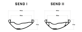
Rim profiles for the new "Send" rims from Black Bird.
Interesting New Rim Extrusion For MTB From Black Bird:

Rims for bicycle wheels have changed a lot in the past 20 years. Probably the most notable advancement has been in materials technology which has allowed for carbon fiber to be utilized as a material suitable for making rims for all manner of bicycles. 

One thing that has come out of the carbon rim designs of recent years is a use of a wider rim bead/edge to help tires not pinch flat when ridden at lowered pressures and on rocky terrain. Carbon is pretty easy to mold into any shape, so this feature was typically reserved for the most expensive of rims for mountain and gravel biking. 

Well, Ibis Cycles has now spun off a new brand and have designed an aluminum extrusion which mimics the same benefits in terms of pinch flat protection for enduro MTB racing, and presumably, any suitable mountain biking style. The brand Ibis created is called "Black Bird" and the new rim model is called the "Send". 

Ibis cleverly engineered a hollow section at the bead, creating the wider, blunter profile that carbon has utilized for a rim bead, but without the weight penalty of a solid aluminum structure there. The Send II model goes one step further with an extrusion featuring a supportive "strut" underneath the rim bead which further stiffens and strengthens the entire rim. 

Comments: This feature of the Black Bird Send rims is not completely unheard of. I searched the internet and found a few examples of hollow rim bead extrusions, but it is rare, and in this application, totally unique. It would be interesting to see this brought over to the gravel riding segment.

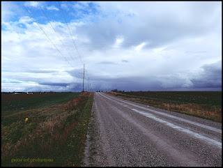
A Country View from 2015
Thinking About 'Riding Plans' Instead Of 'Events':

So, I see events are starting to really push registrations and therefore, commitments, for 2022. Can't say as I blame anyone on either side of the equation here. Promoters are eager to host folks after two years of sparse event choices and riders are eager to rub shoulders with other riders. 

I get that. However; if I've learned anything over this past two year period it is that I dearly love making my own challenges and I don't like the pressures associated with getting ready, preparing to travel, and dealing with logistics that are part and parcel of going to an 'event'. Not to mention the monetary commitment. 

I'm not saying "I'm not doing events." NO! Not at all. I am saying that it will have to be a pretty darn special deal if I am going to put up with the pressures and stresses created by how I deal with events. It's a personal issue, I am sure, and many of you probably don't understand why I wouldn't want to do a bunch of events on gravel. Just think about all the "fun" I'd miss out on by secluding myself to only what I want to put up with. 

I understand completely why many of you might be thinking that. I say- you do you. I'm not saying you should not go all over and see all kinds of people and ride rad gravel events and get all the props for finishing that you deserve. Good on ya! It just doesn't really do much for me anymore. 

I do like riding.On gravel. A LOT! Just not with a number pinned on and all that comes with that. I like stopping, or going, when I like, or when a small group likes to, and not being caught up in big time event pressures. If I want to lay in a ditch and take a nap, (like I did at Gravel Worlds more than once, and elsewhere) I don't want to feel 'bad' about that. If I decide to cut my day short, I don't want to feel like I 'wasted my money' or disappointed anyone rooting for me because it was an event. I don't want to spend hundreds of dollars to travel and stay in a motel when I could camp, or ride somewhere near Waterloo. 

I've done all that and I've stayed around here and have done my own 'riding plans' and I know which way was more fun. So, unless an event is REALLY compelling, yeah...... I'm not real sure I'll be going to anything soon. Not saying 'never going anywhere', far from it. I just have really enjoyed things like my "quest" in 2020 and the ToBHC that I did last year. More of that- less of the organized, big production stuff for me. 

That's a wrap on this Randomonium. Thank you for reading Guitar Ted Productions

Randomonium

 NOTE: Okay folks, if you haven't been around long enough here to know what a "Randomonium" post is, then here is the deal. I ramble, rant, and randomly moan about all things cycling in one, incohesive, bizarre post. "Randomonium", okay?

The Cotic Cascade
Fargo-like Bikes Appear To Satisfy Fat Tire Adventurers:

Recently I've noted that there is a rash of drop bar adventure bike choices out there now which can trace their lineage back to Salsa Cycle's original Fargo. Modernized a bit, to be sure, and set up with all the "Adventure Warts®" one could ever need. (Note- the term "Adventure Warts®" is my technical term for mounting bosses. ) 

The brand-spankin' new Cotic (Like 'psycotic' without the 'psy') Cascade model being one such introduction. This particular model derives more from a Gen 2 Fargo since it has a suspension corrected fork and no single speed option. Then there is the Panorama Cycles Taiga EXP which is more reminiscent of a current Fargo with a single speed option in the sliding rear drop outs. The Singular Gryphon is also set to make a comeback, but I'll have more to say about that one tomorrow along with some words about Panorama's flat bar Taiga bike on Saturday. 

Grinder Nationals Moves Venue:

The US Endurance sanctioning group has held a Gravel Grinder Nationals in Lawrence, Kansas for the past five years. Winners in each category have been awarded National Championship jerseys. Did you know that? Yep! Way before the bunch over at USA Cycling got a whiff of the gravel scene, these US Endurance folks have been paying attention and jumped in a while back. 

Anyway, after five years in the same place, US Endurance is moving Grinder Nationals. Here's a bit from the press release:

"After a 5-year residency in Lawrence, Kansas, the Gravel
Grinder National Championship presented by US Endurance is moving to the MidAtlantic and
scheduled to take place in beautiful Loudoun County, Virginia on May 7, 2022. Registration opens
Tuesday, February 1, 2022 on BikeReg.com

This year’s event, in conjunction with Dirty Kitten Productions, will feature a 100-mile “Grinder
Nationals” championship race and a 30-mile “Mini G” recreational ride on historic Loudoun
County gravel roads. Riders will start at B Chord Brewing Company & Farm in Round Hill, VA then
wind their way through the surrounding areas of Bluemont, Philomont, Purcellville, and Lovettsville.
"

Registration is HERE and you can check out more details at their website

Rim profiles for the new "Send" rims from Black Bird.
Interesting New Rim Extrusion For MTB From Black Bird:

Rims for bicycle wheels have changed a lot in the past 20 years. Probably the most notable advancement has been in materials technology which has allowed for carbon fiber to be utilized as a material suitable for making rims for all manner of bicycles. 

One thing that has come out of the carbon rim designs of recent years is a use of a wider rim bead/edge to help tires not pinch flat when ridden at lowered pressures and on rocky terrain. Carbon is pretty easy to mold into any shape, so this feature was typically reserved for the most expensive of rims for mountain and gravel biking. 

Well, Ibis Cycles has now spun off a new brand and have designed an aluminum extrusion which mimics the same benefits in terms of pinch flat protection for enduro MTB racing, and presumably, any suitable mountain biking style. The brand Ibis created is called "Black Bird" and the new rim model is called the "Send". 

Ibis cleverly engineered a hollow section at the bead, creating the wider, blunter profile that carbon has utilized for a rim bead, but without the weight penalty of a solid aluminum structure there. The Send II model goes one step further with an extrusion featuring a supportive "strut" underneath the rim bead which further stiffens and strengthens the entire rim. 

Comments: This feature of the Black Bird Send rims is not completely unheard of. I searched the internet and found a few examples of hollow rim bead extrusions, but it is rare, and in this application, totally unique. It would be interesting to see this brought over to the gravel riding segment.

A Country View from 2015
Thinking About 'Riding Plans' Instead Of 'Events':

So, I see events are starting to really push registrations and therefore, commitments, for 2022. Can't say as I blame anyone on either side of the equation here. Promoters are eager to host folks after two years of sparse event choices and riders are eager to rub shoulders with other riders. 

I get that. However; if I've learned anything over this past two year period it is that I dearly love making my own challenges and I don't like the pressures associated with getting ready, preparing to travel, and dealing with logistics that are part and parcel of going to an 'event'. Not to mention the monetary commitment. 

I'm not saying "I'm not doing events." NO! Not at all. I am saying that it will have to be a pretty darn special deal if I am going to put up with the pressures and stresses created by how I deal with events. It's a personal issue, I am sure, and many of you probably don't understand why I wouldn't want to do a bunch of events on gravel. Just think about all the "fun" I'd miss out on by secluding myself to only what I want to put up with. 

I understand completely why many of you might be thinking that. I say- you do you. I'm not saying you should not go all over and see all kinds of people and ride rad gravel events and get all the props for finishing that you deserve. Good on ya! It just doesn't really do much for me anymore. 

I do like riding.On gravel. A LOT! Just not with a number pinned on and all that comes with that. I like stopping, or going, when I like, or when a small group likes to, and not being caught up in big time event pressures. If I want to lay in a ditch and take a nap, (like I did at Gravel Worlds more than once, and elsewhere) I don't want to feel 'bad' about that. If I decide to cut my day short, I don't want to feel like I 'wasted my money' or disappointed anyone rooting for me because it was an event. I don't want to spend hundreds of dollars to travel and stay in a motel when I could camp, or ride somewhere near Waterloo. 

I've done all that and I've stayed around here and have done my own 'riding plans' and I know which way was more fun. So, unless an event is REALLY compelling, yeah...... I'm not real sure I'll be going to anything soon. Not saying 'never going anywhere', far from it. I just have really enjoyed things like my "quest" in 2020 and the ToBHC that I did last year. More of that- less of the organized, big production stuff for me. 

That's a wrap on this Randomonium. Thank you for reading Guitar Ted Productions

Monday, September 20, 2021

Fall Views: GTDR/ToBHC - Part 1

Getting an early start
 I had been planning on a big ride for quite some time. I wrote about the route here before, calling it "The Tour of Black Hawk County". That was back in July, but those plans had to be put on hold when I decided I needed to focus in on Gravel Worlds preparations. 

Of course, I would need to recover from the 116 miles I got in at Gravel Worlds, so I planned on maybe getting at this ToBHC idea in a couple of weeks after that. But things didn't pan out for me to get to the route until this past weekend when everything came together for an attempt. I also decided that this would be my "GTDR" for the year. (Guitar Ted Death Ride)

When I say "everything came together" to get this done, I mean that. In the sense of getting the time away from the family, which was foremost of the things I needed to have happen, and in the sense of some testing for RidingGravel.com as well. Then there was the weather. Leading up to last weekend the forecast looked great. Not too hot, decent winds, and most importantly - no rain. So about a week and a half ago I pulled the trigger on September 18th as being the target date for the GTDR/ToBHC ride. 

I was excited. I really had been looking forward to getting this route done for a long time and I had a certain disquiet in my soul over not having gotten around to it in July and August. But I suppose that only forged my resolve deeper and stronger for actually getting the entire route completed. I am thankful for that, because, as you will see, it took everything I had to make the day a success. 

As the day approached, I made final preparations. I was going to take the Noble Bikes GX5 and a couple of test items for Riding Gravel showed up in time to get installed on the bike. Then I looked at the weather. What?!! The low temperature at around the time I wanted to get going was to be 40 degrees?!! It hadn't been that cold for months! But to compound matters, the temperature was to rise up into the low 80's by afternoon. Wow! Did that ever change my plans for what I was going to wear! I would need to ward off early morning cold and be prepared for Summer-like afternoon temperatures! 

With all of that lead-up to this 'event', I did the best I could and I set a start time of 6:00am, which meant I would need lights for the first hour of the ride. My goal was to finish by 5:00pm or sooner. So, with all of that, I set the alarm for 5:00am and laid my clothes out the night before so I could vamoose as soon as possible the next morning. 

Morning blushes as I head East on the GTDR/ToBHC route

Not a cloud in the sky. It would remain this way all day.

I ate a small breakfast and got going early as I ended up waking up at 4:40am instead. I made it to my starting point, which was the City Park in Janesville, Iowa, at the Northwestern end of Black Hawk County. The plan was to take the county line road East, and in this way I figured that I would get a treat of watching the Sun rise. 

There is something about getting up and starting a ride before dawn that I love. I don't do this enough, but I was sure glad I did for this ride because the morning was about as perfect as one could ask for visually. Not a cloud in sight, no wind at all, and the only 'bad' thing was how cold it was. It was really cold! I barely had enough on and riding hard would be the only way I would get warmth in the body. The County maintainer made sure I had plenty of adversity to force me to ride hard too, because the opening miles were on deep, fresh gravel. It was really tough sledding in the dark. 

Eventually there was enough light to grab some scenery shots

The anticipation of the Sun coming up was high. I needed warmth!

The roads were tough. I had a big problem finding any line, and this loose, deep gravel was really working my legs. Fortunately, as I said, there was zero wind to contend with at this point. Had there been any wind at all, especially a headwind of some sort, I would have been in deep trouble as far as finishing the route. I had to burn a lot of matches just to keep up an average speed which would get me to Janesville again by 5:00pm. 

Juuust about there!

And there She is!

By the time the Sun had come up I was working the Northerly bits and was now getting closer to the Northeastern reaches of the county. Finally the roads out here relented with the fresh stuff and I was starting to find some good lines. The route had gone pretty much straight East by this point with only one turn South of a mile, then off Eastward again. Now I would find myself on some pavement for a bit as I worked around the disruptions to "The Grid" caused by the Wapsipinnicon River. 

After a slow-ish start, due to the fresh, deep gravel, I was starting to gain some 'time-in-the-bank' towards my goal of finishing by 5:00pm. I had no computer on my bike, by the way, since my GPS has been smashed. So, I was navigating by my cue sheets I had made and paying attention to the signs on the corners. I knew the roads well enough from having done "The Quest" last year, so mileage to turns wasn't all that important. I did have mileage listed on the cues though, so I could mark my progress against time, which I had available via the Apple Watch on my wrist. 

Finally I started moving South, as I had reached, pretty much, the far Northeastern corner of Black Hawk County. One side of the county was done! Now onward.......

Tomorrow: Part two of my GTDR/ToBHC

Fall Views: GTDR/ToBHC - Part 1

Getting an early start
 I had been planning on a big ride for quite some time. I wrote about the route here before, calling it "The Tour of Black Hawk County". That was back in July, but those plans had to be put on hold when I decided I needed to focus in on Gravel Worlds preparations. 

Of course, I would need to recover from the 116 miles I got in at Gravel Worlds, so I planned on maybe getting at this ToBHC idea in a couple of weeks after that. But things didn't pan out for me to get to the route until this past weekend when everything came together for an attempt. I also decided that this would be my "GTDR" for the year. (Guitar Ted Death Ride)

When I say "everything came together" to get this done, I mean that. In the sense of getting the time away from the family, which was foremost of the things I needed to have happen, and in the sense of some testing for RidingGravel.com as well. Then there was the weather. Leading up to last weekend the forecast looked great. Not too hot, decent winds, and most importantly - no rain. So about a week and a half ago I pulled the trigger on September 18th as being the target date for the GTDR/ToBHC ride. 

I was excited. I really had been looking forward to getting this route done for a long time and I had a certain disquiet in my soul over not having gotten around to it in July and August. But I suppose that only forged my resolve deeper and stronger for actually getting the entire route completed. I am thankful for that, because, as you will see, it took everything I had to make the day a success. 

As the day approached, I made final preparations. I was going to take the Noble Bikes GX5 and a couple of test items for Riding Gravel showed up in time to get installed on the bike. Then I looked at the weather. What?!! The low temperature at around the time I wanted to get going was to be 40 degrees?!! It hadn't been that cold for months! But to compound matters, the temperature was to rise up into the low 80's by afternoon. Wow! Did that ever change my plans for what I was going to wear! I would need to ward off early morning cold and be prepared for Summer-like afternoon temperatures! 

With all of that lead-up to this 'event', I did the best I could and I set a start time of 6:00am, which meant I would need lights for the first hour of the ride. My goal was to finish by 5:00pm or sooner. So, with all of that, I set the alarm for 5:00am and laid my clothes out the night before so I could vamoose as soon as possible the next morning. 

Morning blushes as I head East on the GTDR/ToBHC route

Not a cloud in the sky. It would remain this way all day.

I ate a small breakfast and got going early as I ended up waking up at 4:40am instead. I made it to my starting point, which was the City Park in Janesville, Iowa, at the Northwestern end of Black Hawk County. The plan was to take the county line road East, and in this way I figured that I would get a treat of watching the Sun rise. 

There is something about getting up and starting a ride before dawn that I love. I don't do this enough, but I was sure glad I did for this ride because the morning was about as perfect as one could ask for visually. Not a cloud in sight, no wind at all, and the only 'bad' thing was how cold it was. It was really cold! I barely had enough on and riding hard would be the only way I would get warmth in the body. The County maintainer made sure I had plenty of adversity to force me to ride hard too, because the opening miles were on deep, fresh gravel. It was really tough sledding in the dark. 

Eventually there was enough light to grab some scenery shots

The anticipation of the Sun coming up was high. I needed warmth!

The roads were tough. I had a big problem finding any line, and this loose, deep gravel was really working my legs. Fortunately, as I said, there was zero wind to contend with at this point. Had there been any wind at all, especially a headwind of some sort, I would have been in deep trouble as far as finishing the route. I had to burn a lot of matches just to keep up an average speed which would get me to Janesville again by 5:00pm. 

Juuust about there!

And there She is!

By the time the Sun had come up I was working the Northerly bits and was now getting closer to the Northeastern reaches of the county. Finally the roads out here relented with the fresh stuff and I was starting to find some good lines. The route had gone pretty much straight East by this point with only one turn South of a mile, then off Eastward again. Now I would find myself on some pavement for a bit as I worked around the disruptions to "The Grid" caused by the Wapsipinnicon River. 

After a slow-ish start, due to the fresh, deep gravel, I was starting to gain some 'time-in-the-bank' towards my goal of finishing by 5:00pm. I had no computer on my bike, by the way, since my GPS has been smashed. So, I was navigating by my cue sheets I had made and paying attention to the signs on the corners. I knew the roads well enough from having done "The Quest" last year, so mileage to turns wasn't all that important. I did have mileage listed on the cues though, so I could mark my progress against time, which I had available via the Apple Watch on my wrist. 

Finally I started moving South, as I had reached, pretty much, the far Northeastern corner of Black Hawk County. One side of the county was done! Now onward.......

Tomorrow: Part two of my GTDR/ToBHC

Monday, July 19, 2021

Country Views: Recon For ToBHC

Embarking from LaPorte City to save time.
 Saturday I introduced the idea I had for a "Tour of Black Hawk County" via mostly gravel. In that post I described how certain parts of the route were 'compromised' due to rivers and highways getting in the way combined with a lack of connected gravel roads. One of those problem areas was down in the Southeastern corner of the county.

I had a route idea planned but I thought maybe I could do better. Also, curiously the route planner would not allow me to route through a mile section of gravel in this area. It kept auto-routing around that road on to a paved section North of it. I zoomed in on the area and noted that there was a stream at the exact point that I was allowed to route to. Interesting...... Perhaps a bridge has been removed? The DOT maps did not show this. But then, I know how the DOT maps are often wrong. It is rarer for a GPS routing service to catch that though. Maybe this one did? I'd have to investigate for myself. 

As long as I was down there, I figured I could investigate another route possibility. The county border road actually seemed to terminate juuuust North of the Cedar Valley Nature Trail. Investigating further, I noted that by looking at Google Earth that a path from the road terminus down to the CVNT existed at one time recently. (Not knowing when the image was taken, I was assuming) Then there was another possibility with a rock quarry which abutted the bike trail and seemed to have an access to the county line road. 

So, with all of those tantalizing options to explore, which- if even one worked out, I would eliminate a huge bit of pavement, I left on Saturday afternoon to start my ride from La Porte City. It was typically hot and humid with a light Southeastern breeze. The air has been hazy here, likely from wildfires out West. The sky had a weird, unfocused look to it. With the Noble Bikes GX5, I took off into the haze to go in search of options. 

Using the CVNT would get me across the Cedar River on this bridge.

I have to admit that the section of the CVNT South of the Cedar crossing is interesting.

Getting South of La Porte City on the CVNT was going to be new territory for me. I had never ridden this trail before South of there, and that is kind of a crazy thought. In fact, as I rode it I figured that I should have ridden this section before. 15 years prior I was reconning the course for the third Trans Iowa. That course used the CVNT between Brandon and La Porte City, but I just gambled on it being good, and I never rode it to recon it then. This ride, then, was sort of a make-up ride of sorts as well as recon for my ToBHC. 

The CVNT past the Cedar River crossing South is pea gravel and compacted dirt. It also is a bit more scenic than the stretch North to Evansdale. I liked it better, but.....it still is rail-trail, which means it is not my favorite thing in the world to ride. Too flat!

A nice overlook at a rest stop along the CVNT of the Cedar River.

Either this is a gravity fed loading station for railway grain cars, or it is something outta science fiction!

The two CVNT related options turned out to be busts. The quarry was at a level higher than the trail and had no obvious access exit/entry to the trail. The road, actually Black Hawk/Bucahanan Road, terminates at a farm which has about a 100 yard marked "Private Drive Way" which continues on from the end of the road and which dumps right out on the CVNT. Man! just that short distance and I could have sliced off about three miles of the route along with some pavement. Oh well......

Onward to check out if there really is a bridge out or what...... 

The dust cloud up the road is from a pick-up driven by a not very nice man.

Barns For Jason #1

I reached the North bound gravel I would need to use now and went a mile or so on that before I would know about the bridge. But before that, I stopped to double check things on my iPhone map. While I was sitting there a white pick-up truck came up from behind me and slow rolled along side as I had mounted up and was rolling now. The window came down and "Mr. Smarty-Pants" made a remark about how the bicycle trail was 'back there' and went the other directions while he was laughing. Nice....

You know, in my head I am thinking, "What a jack-ass!", but you know, that wouldn't be nice back. So, instead, I just said, "Yeah, I know that, but I'm okay. I like riding on gravel. Thanks!", and he rolled on all the while visibly laughing at me. Whatever dude............

"Not all who wander are lost."

And not all who drive white pick-up trucks have any idea what I am doing. So, I let it go and rode onward. Unfortunately, the bridge was out, and the sign looked pretty permanent and old. So, that option was a bust as well. However; my bail-out ride back to La Porte showed me something unexpected.

Barns For Jason #2: This was on some of that pavement I was hoping to eliminate from the route.

McChrane Road looking West

I had previously decided to loop back to LaPorte City by revisiting a few roads I had done previously on "The Quest" last Fall in this area. While I was riding along, the thought occurred to me- "Why not use this instead of the CVNT?". I didn't know if there would be an advantage to it from the getting rid of pavement standpoint, because there was going to be a stretch of pavement coming into La Porte City, but why not consider it?

The idea would eliminate having to go into Buchanan County down there, and it would eliminate some pavement which vehicles would be going at highway speeds where there is no paved shoulder. The paved bit coming into La Porte has a paved shoulder for most of its way into town, with the exception of the last mile, which is where speed limits for the cars start to take effect. There is about a mile and a half of chip seal before the paved section which is little traveled. Plus, it would trade mileage, essentially, paved for paved, with the CVNT where it is also pavement. 

Overall, the 'North of the Cedar' approach loses about a mile and a third of pavement too. I think I will be modifying the route to reflect this. I like it better because it keeps the route in Black Hawk County. This is a tour of Black Hawk County after all. So, I was glad that I did the recon despite the three options not working out.

Country Views: Recon For ToBHC

Embarking from LaPorte City to save time.
 Saturday I introduced the idea I had for a "Tour of Black Hawk County" via mostly gravel. In that post I described how certain parts of the route were 'compromised' due to rivers and highways getting in the way combined with a lack of connected gravel roads. One of those problem areas was down in the Southeastern corner of the county.

I had a route idea planned but I thought maybe I could do better. Also, curiously the route planner would not allow me to route through a mile section of gravel in this area. It kept auto-routing around that road on to a paved section North of it. I zoomed in on the area and noted that there was a stream at the exact point that I was allowed to route to. Interesting...... Perhaps a bridge has been removed? The DOT maps did not show this. But then, I know how the DOT maps are often wrong. It is rarer for a GPS routing service to catch that though. Maybe this one did? I'd have to investigate for myself. 

As long as I was down there, I figured I could investigate another route possibility. The county border road actually seemed to terminate juuuust North of the Cedar Valley Nature Trail. Investigating further, I noted that by looking at Google Earth that a path from the road terminus down to the CVNT existed at one time recently. (Not knowing when the image was taken, I was assuming) Then there was another possibility with a rock quarry which abutted the bike trail and seemed to have an access to the county line road. 

So, with all of those tantalizing options to explore, which- if even one worked out, I would eliminate a huge bit of pavement, I left on Saturday afternoon to start my ride from La Porte City. It was typically hot and humid with a light Southeastern breeze. The air has been hazy here, likely from wildfires out West. The sky had a weird, unfocused look to it. With the Noble Bikes GX5, I took off into the haze to go in search of options. 

Using the CVNT would get me across the Cedar River on this bridge.

I have to admit that the section of the CVNT South of the Cedar crossing is interesting.

Getting South of La Porte City on the CVNT was going to be new territory for me. I had never ridden this trail before South of there, and that is kind of a crazy thought. In fact, as I rode it I figured that I should have ridden this section before. 15 years prior I was reconning the course for the third Trans Iowa. That course used the CVNT between Brandon and La Porte City, but I just gambled on it being good, and I never rode it to recon it then. This ride, then, was sort of a make-up ride of sorts as well as recon for my ToBHC. 

The CVNT past the Cedar River crossing South is pea gravel and compacted dirt. It also is a bit more scenic than the stretch North to Evansdale. I liked it better, but.....it still is rail-trail, which means it is not my favorite thing in the world to ride. Too flat!

A nice overlook at a rest stop along the CVNT of the Cedar River.

Either this is a gravity fed loading station for railway grain cars, or it is something outta science fiction!

The two CVNT related options turned out to be busts. The quarry was at a level higher than the trail and had no obvious access exit/entry to the trail. The road, actually Black Hawk/Bucahanan Road, terminates at a farm which has about a 100 yard marked "Private Drive Way" which continues on from the end of the road and which dumps right out on the CVNT. Man! just that short distance and I could have sliced off about three miles of the route along with some pavement. Oh well......

Onward to check out if there really is a bridge out or what...... 

The dust cloud up the road is from a pick-up driven by a not very nice man.

Barns For Jason #1

I reached the North bound gravel I would need to use now and went a mile or so on that before I would know about the bridge. But before that, I stopped to double check things on my iPhone map. While I was sitting there a white pick-up truck came up from behind me and slow rolled along side as I had mounted up and was rolling now. The window came down and "Mr. Smarty-Pants" made a remark about how the bicycle trail was 'back there' and went the other directions while he was laughing. Nice....

You know, in my head I am thinking, "What a jack-ass!", but you know, that wouldn't be nice back. So, instead, I just said, "Yeah, I know that, but I'm okay. I like riding on gravel. Thanks!", and he rolled on all the while visibly laughing at me. Whatever dude............

"Not all who wander are lost."

And not all who drive white pick-up trucks have any idea what I am doing. So, I let it go and rode onward. Unfortunately, the bridge was out, and the sign looked pretty permanent and old. So, that option was a bust as well. However; my bail-out ride back to La Porte showed me something unexpected.

Barns For Jason #2: This was on some of that pavement I was hoping to eliminate from the route.

McChrane Road looking West

I had previously decided to loop back to LaPorte City by revisiting a few roads I had done previously on "The Quest" last Fall in this area. While I was riding along, the thought occurred to me- "Why not use this instead of the CVNT?". I didn't know if there would be an advantage to it from the getting rid of pavement standpoint, because there was going to be a stretch of pavement coming into La Porte City, but why not consider it?

The idea would eliminate having to go into Buchanan County down there, and it would eliminate some pavement which vehicles would be going at highway speeds where there is no paved shoulder. The paved bit coming into La Porte has a paved shoulder for most of its way into town, with the exception of the last mile, which is where speed limits for the cars start to take effect. There is about a mile and a half of chip seal before the paved section which is little traveled. Plus, it would trade mileage, essentially, paved for paved, with the CVNT where it is also pavement. 

Overall, the 'North of the Cedar' approach loses about a mile and a third of pavement too. I think I will be modifying the route to reflect this. I like it better because it keeps the route in Black Hawk County. This is a tour of Black Hawk County after all. So, I was glad that I did the recon despite the three options not working out.